By visiting our site, you agree to our privacy policy regarding cookies, anonymous tracking statistics
Earthline has an extensive proprietary code base which, in conjunction with industry standard geophysical software, is used in all areas of its business. Applications have been developed for data QC, processing, interpretation, and the integration of potential field data with seismic and other key datasets.
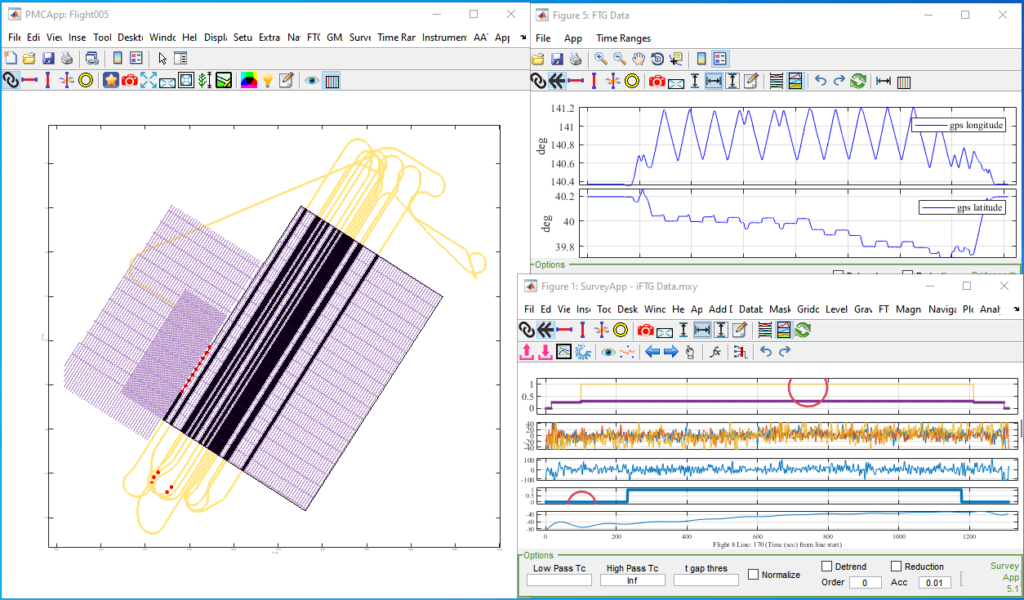
Earthline has developed geophysical software for use in the field during FTG and eFTG surveys. This geophysical software integrates with Lockheed Martin’s processing tools to manage, collate, process and quality assess survey data from the FTG and eFTG instruments. The software can perform interim analysis that is essential for providing clients with fast turn-around maps of the gravity and gravity gradient fields. These fast-tracked results allow clients to monitor survey progress and identify possible areas for detailed infill acquisition.
Algorithms have been developed specifically to process data from the Gravity Module Assembly (GMA) that accompanies the FTG and eFTG instruments. This has been critical in forming an accurate representation of the gravity field over large distances and gave rise to the iFTG instrument which allows integrated FTG and scalar gravity data to be recorded within a single system on the same
stabilised platform.


Methods and associated geophysical software have been developed at Earthline Consulting to maximise the resolution and the information within the data collected during gradiometry surveys. These methods exploit the mathematical relationships between the numerous data channels that are recorded by FTG and eFTG instruments.
Tensor processing methods are too specialised to be available in commercial geophysical software packages. The know-how and methods that allow large datasets to be processed efficiently is part of our internal intellectual property. The image to the left shows how full tensor processing can interpolate the gravity field in between
survey lines.
Earthline has processed over a million kilometres of conventional gravity and magnetic data. During this work, many proprietary methods, algorithms and workflows have been developed to ensure that the best possible data products can be produced from the raw data.


LiDAR (Light Detection And Ranging) data is acquired alongside iFTG and eFTG instruments and is used to build high resolution digital terrain models required to accurately correct the gravity gradient measurements for topographic interference.
Earthline has developed powerful LiDAR processing algorithms to work alongside industry standard LiDAR software. This allows automated processing to ensure a rapid delivery of its geophysical data products.
Traditionally, the terrain correction is where LiDAR’s involvement ends for the geophysical survey. But, with our geophysical software, Earthline Consulting can maximise the use of acquired data for its clients.
A high-resolution ground surface model contains a vast amount of information, and our software allows us to create datasets for other purposes such as urban planning, environmental monitoring, or just a clearer understanding of a region’s topography.
We use quality control software to monitor survey progress and the data quality of marine gravity and magnetic acquisition. The software allows raw data (navigation, gravity and magnetics) to be collated, plotted and processed on a daily basis. This geophysical software is used to generate reports which are sent regularly to clients during a marine
acquisition project.

Algorithms and associated software have been developed to design and plan airborne surveys. This includes the placement of survey and tie lines within a pre-defined area, the allocation of infill lines (over areas of special interest) and the determination of the optimum flying elevation.


Earthline has developed its own interpretation techniques and geophysical software with a focus on building geologically realistic
3D models.
Emphasis has been placed on an interactive approach where the interpreter is key in crafting geological models using all available information (survey data, seismic data, well logs, existing geological interpretations). This approach allows the interpreter to control the information and associated uncertainties with proper geological oversight. The techniques and software provide the means for integrating seismic interpretations and other geological constraints with potential field data when building 3D Earth models.