By visiting our site, you agree to our privacy policy regarding cookies, anonymous tracking statistics
Airborne LiDAR Surveys provide an engineering-grade measurement of the 3D ground surface. This is essential in providing a highly accurate terrain correction for our airborne geophysical datasets.
Digital terrain models of the bare Earth and vegetation cover are used to derive the final gradiometry products. They also have value beyond airborne surveys for seismic planning, infrastructure mapping, and environmental assessment.
LiDAR is an acronym for ‘Light Detection and Ranging’ or ‘Laser Imaging, Detection, and Ranging’. It is a technique for determining ranges (distance) by targeting an object or a surface with a laser and measuring the time for the reflected light to return to the receiver. It can also be used to create digital 3D models of areas on the Earth’s surface.
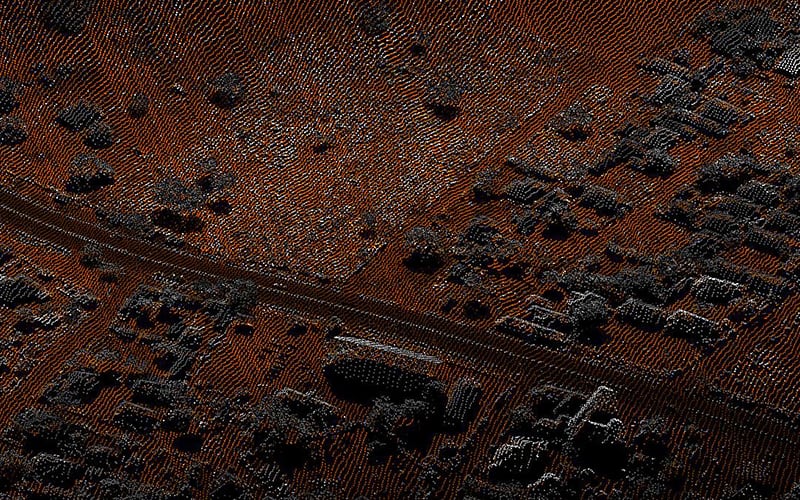
Airborne LiDAR Surveys use a laser scanner attached to an aircraft during flight. The data collected from the laser scanner can give accurate information on the shape of the Earth’s surface, which helps in creating a 3D point cloud model of the landscape. This is currently the most detailed and accurate method of creating digital elevation models over large areas.
Airborne LiDAR surveys are particularly useful when there is extensive vegetation cover, especially when tree canopy cover obscures surface morphology.


The resultant models taken from airborne LiDAR surveys have many uses, including:
Accurate terrain corrections for gravity and gravity gradiometry surveys: High-resolution gravity and gravity gradiometry surveys require accurate corrections to remove the effects of the topography and, therefore, reveal the signal from the sub-surface geology. LiDAR-derived ground elevation models are ideal to achieve this and, therefore, maximise the value of the survey data.
When compared to airborne LiDAR surveys, alternative elevation models (for example, SRTM and other satellite-based techniques) do not give as accurate a representation of the ground surface in areas of vegetation. This can, therefore, cause errors and add terrain-model noise when used as the basis of a terrain correction.
Geology and Soil Studies: Detection of subtle topographic features such as surface fault expressions, river terraces and channel banks, glacial landforms and the measurements of elevation changes between repeat surveys allow the study of the physical and chemical processes that shape landscapes.
Airborne LiDAR surveys can map faults whose surface expressions are obscured by vegetation or are too subtle to be seen by other technology.
LiDAR surveys have also been widely used for rock mass characterisation and slope change detection in rock mechanics.
Mining: The calculation of ore volumes is accomplished by periodic (monthly) LiDAR scanning in areas of ore removal, then comparing surface data to the previous scan.
Biology and conservation: Applications include vegetation coverage estimates, forest canopy height mapping, biomass measurements, and leaf area determination. LiDAR survey data can also be used to differentiate between tree types.
Renewables: Results from LiDAR surveys can also be used to assist city planners and developers in optimising solar photovoltaic systems by defining appropriate rooftop locations and determining shading losses.
Access and Infrastructure Planning: The accuracy of LiDAR survey data allows the rugosity (roughness) of the ground surface to be mapped over large areas. This has played an important role in the planning of ground surveys (seismic, for example) and in the siting of ground-based infrastructure.
Find out more about what LiDAR is used for.
At Earthline Consulting, we specialise in all areas of ground surveying and measurement, one of which is airborne LiDAR surveys. If you would like more information, feel free to contact us.